Overview of DOTA-v1.5
DOTA-v1.5 contains 0.4 million annotated object instances within 16 categories, which is an updated version of DOTA-v1.0. Both of them use the same aerial images but DOTA-v1.5 has revised and updated the annotation of objects, where many small object instances about or below 10 pixels that were missed in DOTA-v1.0 have been additionally annotated. The categories of DOTA-v1.5 is also extended. Concretely, the category of container crane is added.
Image Source and Usage License
In consistent with DOTA-v.1.0, the images in DOTA-v1.5 are mainly collected from the Google Earth, satellite JL-1, and satellite GF-2 of the China Centre for Resources Satellite Data and Application. Use of the images from Google Earth must respect the corresponding terms of use: "Google Earth" terms of use. All images and their associated annotations in DOTA-v1.5 can be used for academic purposes only, but any commercial use is prohibited.
Object Category
The object categories in DOTA-v1.5 include: plane, ship, storage tank, baseball diamond, tennis court, basketball court, ground track field, harbor, bridge, small vehicle, large vehicle, helicopter, roundabout, soccer ball field, swimming pool and container crane.
Annotation format
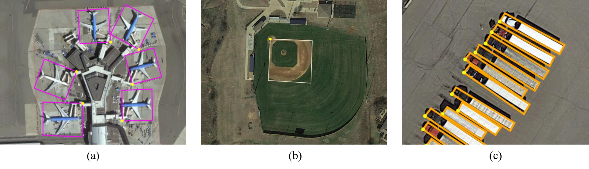
In the dataset, each instance's location is annotated by a quadrilateral bounding boxes, which can be denoted as "x 1, y 1, x 2, y 2, x 3, y 3, x 4, y 4" where (x i, y i) denotes the positions of the oriented bounding boxes' vertices in the image. The vertices are arranged in a clockwise order. The following is the Visualization of adopted annotation method. The yellow point represents the starting point. which refers to: (a) top left corner of a plane, (b) top left corner of a large vehicle diamond, (c) the center of sector-shaped baseball.
Except the annotation of location, category label is assigned for each instance, which comes from one of the above 15 selected categories, and meanwhile a difficult label is provided which indicates whether the instance is difficult to be detected(1 for difficult, 0 for not difficult). Annotations for an image are saved in a text file with the same file name. At the first line, 'imagesource'(from GoogleEarth, GF-2 or JL-1) is given. At the second line, ’gsd’(ground sample distance, the physical size of one image pixel, in meters) is given. Note if the 'gsd' is missing, it is annotated to be 'null'. From third line to last line in annotation text file, annotation for each instance is given. The annotation format is:
'gsd':gsd
x 1, y 1, x 2, y 2, x 3, y 3, x 4, y 4, category, difficult
x 1, y 1, x 2, y 2, x 3, y 3, x 4, y 4, category, difficult
...
Development kit
We have provided development kit that includes some useful functions such as visualizing data, calculating mAP, splitting and merging data.
Download
You can download DOTA-v1.5 from either Baidu Drive or Google Drive, according to your network connections. Make sure you download the labelTxt of version 1.5.
- DOTA-v1.5 on Baidu Drive: Training set, Validation set, Testing images
- DOTA-v1.5 on Google Drive: Training set, Validation set, Testing images